NYZ080
Current watches, warnings, and advisories for Southwest Suffolk (NYZ080) NY
Air Quality Alert issued July 17 at 3:28PM EDT by NWS Upton NY
The New York State Department of Environmental Conservation hasissued an Air Quality Health Advisory
for the following counties:New York, Bronx, Kings, Queens, Richmond, Nassau, Suffolk,Westchester, Rockland, Orange, Putnam.until
midnight EDT Saturday night.Air quality levels in outdoor air are predicted to be greater
thanan Air Quality Index value of 100 for the pollutant of FineParticulates. The Air
Quality Index, or AQI, was created as an easyway to correlate levels of different
pollutants to one scale. Thehigher the AQI value, the greater the health concern.When pollution
levels are elevated, the New York State Department ofHealth recommends that individuals consider limiting
strenuousoutdoor physical activity to reduce the risk of adverse healtheffects. People who may be
especially sensitive to the effects ofelevated levels of pollutants include the very young, and
those withpreexisting respiratory problems such as asthma or heart disease.Those with symptoms should consider
consulting their personalphysician.For additional information, please visit the New York StateDepartment of Environmental Conservation
website at,https://on.ny.gov/nyaqi, or call the Air Quality Hotline at1 800 5 3 5, 1 3 4 5.
Air Quality Alert
Air Quality Alert issued July 17 at 3:20PM EDT by NWS Upton NY
The New York State Department of Environmental Conservation hasissued an Air Quality Health Advisory
for the following counties:New York, Bronx, Kings, Queens, Richmond, Nassau, Suffolk,Westchester, Rockland, Orange, Putnam.until
midnight EDT tonight.Air quality levels in outdoor air are predicted to be greater thanan
Air Quality Index value of 100 for the pollutant of FineParticulates. The Air Quality
Index, or AQI, was created as an easyway to correlate levels of different pollutants
to one scale. Thehigher the AQI value, the greater the health concern.When pollution levels
are elevated, the New York State Department ofHealth recommends that individuals consider limiting strenuousoutdoor
physical activity to reduce the risk of adverse healtheffects. People who may be especially
sensitive to the effects ofelevated levels of pollutants include the very young, and those
withpreexisting respiratory problems such as asthma or heart disease.Those with symptoms should consider consulting
their personalphysician.For additional information, please visit the New York StateDepartment of Environmental Conservation website
at,https://on.ny.gov/nyaqi, or call the Air Quality Hotline at1 800 5 3 5, 1 3 4 5.
Air Quality Alert
Rip Current Statement issued July 17 at 2:45PM EDT until July 18 at 9:00PM EDT by NWS Upton NY
* WHAT...
Dangerous rip currents expected.* WHERE...
Kings (Brooklyn), Southwest Suffolk, SoutheastSuffolk, Southern Queens and Southern Nassau Counties.* WHEN...
From Saturday morning through Saturday evening.* IMPACTS...
Life-threatening rip currents are likely for allpeople entering the surf zone. Anyone visiting the
beachesshould stay out of the surf. Rip currents can sweep even thebest swimmers away
from shore into deeper water.* ADDITIONAL DETAILS...
The high rip current risk is expected tocontinue for Suffolk county on Sunday.
Rip Current Statement
Air Quality Alert issued July 17 at 2:45PM EDT by NWS Upton NY
The New York State Department of Environmental Conservation hasissued an Air Quality Health Advisory
for the following counties:New York, Bronx, Kings, Queens, Richmond, Nassau, Suffolk,Westchester, Rockland, Orange, Putnam.until
midnight EDT tonight.Air quality levels in outdoor air are predicted to be greater thanan
Air Quality Index value of 100 for the pollutant of FineParticulates. The Air Quality
Index, or AQI, was created as an easyway to correlate levels of different pollutants
to one scale. Thehigher the AQI value, the greater the health concern.When pollution levels
are elevated, the New York State Department ofHealth recommends that individuals consider limiting strenuousoutdoor
physical activity to reduce the risk of adverse healtheffects. People who may be especially
sensitive to the effects ofelevated levels of pollutants include the very young, and those
withpreexisting respiratory problems such as asthma or heart disease.Those with symptoms should consider consulting
their personalphysician.For additional information, please visit the New York StateDepartment of Environmental Conservation website
at,https://on.ny.gov/nyaqi, or call the Air Quality Hotline at1 800 5 3 5, 1 3 4 5.
Air Quality Alert
Air Quality Alert issued July 17 at 9:51AM EDT by NWS Upton NY
The New York State Department of Environmental Conservation hasissued an Air Quality Health Advisory
for the following counties:New York, Bronx, Kings, Queens, Richmond, Nassau, Suffolk,Westchester, Rockland, Orange, Putnam.until
midnight EDT tonight.Air quality levels in outdoor air are predicted to be greater thanan
Air Quality Index value of 100 for the pollutant of FineParticulates. The Air Quality
Index, or AQI, was created as an easyway to correlate levels of different pollutants
to one scale. Thehigher the AQI value, the greater the health concern.When pollution levels
are elevated, the New York State Department ofHealth recommends that individuals consider limiting strenuousoutdoor
physical activity to reduce the risk of adverse healtheffects. People who may be especially
sensitive to the effects ofelevated levels of pollutants include the very young, and those
withpreexisting respiratory problems such as asthma or heart disease.Those with symptoms should consider consulting
their personalphysician.For additional information, please visit the New York StateDepartment of Environmental Conservation website
at,https://on.ny.gov/nyaqi, or call the Air Quality Hotline at1 800 5 3 5, 1 3 4 5.
Air Quality Alert
****************
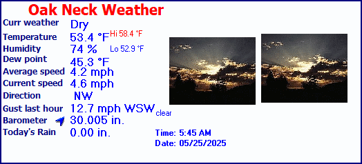
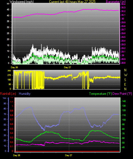
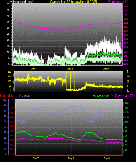
| Oak Neck Lane Weather | |||
|---|---|---|---|
| LAST READING AT TIME: 8:20 PM DATE: July 17 2026, time of next update: 8:25 pm | |||
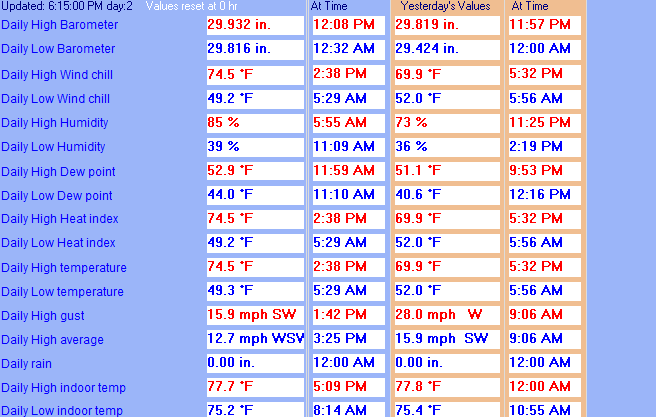
| Current Weather | Night time/Dry | Current Temperature | 78.7°F (25.9°C) |
| Maximum Temperature (since midnight) | 89.0°F at: 1:51 PM | Minimum Temperature (since midnight) | 66.7°F at: 5:17 AM |
| Average windspeed (ten minute) | 3.3 mph | Wind Direction (ten minute) | WSW (257°) |
| Windchill Temperature | 78.7°F | Maximum Gust (last hour) | 8.6 mph at: 7:27 PM |
| Maximum Gust (since midnight) | 13.8 mph at: 11:57 AM | Maximum 1 minute average (since midnight) | 9.3 mph at: 11:53 AM |
| Rainfall (last hour) | 0.00 in. (0.0 mm) | Rainfall (since midnight) | 0.00 in. (0.0 mm) --- |
| Rainfall This month | 0.00 in. (0.0 mm) | Rainfall To date this year | 0.00 in. (0.0 mm) |
| Maximum rain per minute (last hour) | 0.00 in/min | Maximum rain per hour (last 6 hours) | 0.00 in/hour |
| Yesterdays rainfall | 0.00 in | Barometer corrected to msl | 29.988 in. (1015.5 hPa) |
| Pressure change | +0.01 in. (last hour) | Trend (last hour) | STEADY |
| Pressure change (last 12 hours) | -0.00 in | Pressure change (last 6 hours) | +0.00 in |
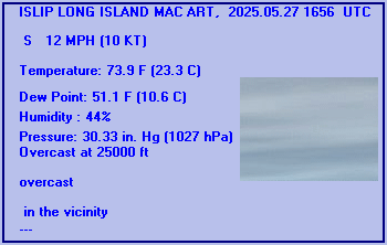
Expires:202607180900;;135705
FPUS51 KOKX 171916
ZFPOKX

Zone Forecast Product
National Weather Service New York NY
316 PM EDT Fri Jul 17 2026


NYZ080-180900-
Southwest Suffolk-
316 PM EDT Fri Jul 17 2026

...HIGH RIP CURRENT RISK IN EFFECT FROM SATURDAY MORNING THROUGH
SATURDAY EVENING...

.TONIGHT...Partly cloudy. Smoke this evening, then areas of smoke
after midnight. Lows around 70. South winds 5 to 10 mph.
.SATURDAY...Partly sunny in the morning, then showers likely with
a chance of thunderstorms in the afternoon. Smoke in the morning,
then areas of smoke in the afternoon. Humid with highs in the
lower 80s. South winds 15 to 20 mph with gusts up to 30 mph.
Chance of rain 70 percent.
.SATURDAY NIGHT...Patchy smoke in the evening. Showers with a
chance of thunderstorms in the evening, then showers likely with
a slight chance of thunderstorms after midnight. Humid with lows
in the lower 70s. Southwest winds 15 to 20 mph with gusts up to
30 mph. Chance of rain 90 percent.
.SUNDAY...Sunny. Highs in the mid 80s. Northwest winds 10 to
15 mph.
.SUNDAY NIGHT...Mostly clear. Lows in the mid 60s. Northwest
winds 5 to 10 mph.
.MONDAY...Sunny. Highs in the lower 80s.
.MONDAY NIGHT...Partly cloudy. Lows in the upper 60s.
.TUESDAY...Partly sunny in the morning, then mostly cloudy with a
chance of showers and thunderstorms in the afternoon. Highs in
the lower 80s. Chance of rain 50 percent.
.TUESDAY NIGHT...Showers with a chance of thunderstorms. Lows in
the lower 70s. Chance of rain 90 percent.
.WEDNESDAY...Showers. Highs in the lower 80s. Chance of rain
90 percent.
.WEDNESDAY NIGHT...Mostly cloudy in the evening, then becoming
partly cloudy. A chance of showers. Lows in the upper 60s. Chance
of rain 50 percent.
.THURSDAY...Mostly sunny. Highs in the lower 80s.
.THURSDAY NIGHT...Partly cloudy. Lows in the upper 60s.
.FRIDAY...Sunny. Highs in the lower 80s.

$$


NEW YORK CITY CENTRAL PARK, NY, United States (KNYC) 40-47N 073-58W 48M
Jul 17, 2026 - 07:51 PM EDT / 2026.07.17 2351 UTC
Wind: from the NNW (340 degrees) at 5 MPH (4 KT):0
Visibility: 10 mile(s):0
Sky conditions: clear
Temperature: 81.0 F (27.2 C)
Dew Point: 51.1 F (10.6 C)
Relative Humidity: 35%
Pressure (altimeter): 30.03 in. Hg (1016 hPa)
Pressure tendency: 0.01 inches (0.3 hPa) lower than three hours ago
ob: KNYC 172351Z AUTO 34004KT 10SM CLR 27/11 A3003 RMK AO2 SLP159 T02720106 10300 20272 56003
cycle: 0
ISLIP LONG ISLAND MAC ART, NY, United States (KISP) 40-48N 073-06W 43M
Jul 17, 2026 - 07:56 PM EDT / 2026.07.17 2356 UTC
Wind: from the SW (220 degrees) at 7 MPH (6 KT):0
Visibility: 9 mile(s):0
Sky conditions: mostly cloudy
Temperature: 75.0 F (23.9 C)
Dew Point: 62.1 F (16.7 C)
Relative Humidity: 64%
Pressure (altimeter): 30.02 in. Hg (1016 hPa)
Pressure tendency: 0.00 inches (0.1 hPa) lower than three hours ago
ob: KISP 172356Z 22006KT 9SM BKN250 24/17 A3002 RMK AO2 SLP164 T02390167 10289 20239 55001
cycle: 0
Use the RELOAD facility on your browser to retrieve the latest data.