Follow us at facebook.com/NYCTrackbook
History BehindThe Book
In 1975 I was doing a grade 10 high school project on urban transportation. Living in Montréal, a city whose Métro has world-renowned architectural merit and quiet-running rubber tires, I naturally chose to write my work on the topic of the New York subway system <grin>. When I wrote to the New York City Transit Authority asking for any maps or plans I could use in my project, I was surprised to receive, some 2 weeks later, a huge envelope stuffed with goodies. Amongst these goodies was a track map, measuring some 12 feet high by about 4 feet wide, and dating originally from just before unification* in 1940 (revised to November, 1967).
[* unification occurred June 1, 1940, when the privately-run Interborough Rapid Transit Company (IRT - today's numbered routes) and Brooklyn-Manhattan Transportation companies joined the city-run Independent subway, under the umbrella of one public transportation agency]
I got an A.
That map remained in my imagination for a long time after that, however. Unfortunately, I could never think of anything much to do with it. Until about October, 1995.
Starting then, and continuing to this day, I have worked on scanning and re-drawing the entire map, and making it available on line via the Internet. Much has been added (new construction like the Archer-Parsons extension and the 63rd St. tunnel), sadly some has been taken away (Culver shuttle, 3rd Av. el), and a whole lot has been corrected from personal verification.
These online maps were very well received by the internet community, but I was still being asked repeatedly to make them available in printed form. Thus the beginnings of this work. I started going after a printed version around Christmas, 1996. I had to convert all my colour maps back into B&W, but this time as separate files. This has subsequently proven to be a mistake, since whenever I verified something as being different than what was printed, I now had to make the corrections twice, not once. Arrrrgh! make that three times if you also include the overall combination maps, and 4 times if a detail map was also involved! Therefore for the moment, I'm leaving the online maps alone -- errors and all.
Well, after much blood, sweat, tears, pleading, moaning and sheer luck, I got everything ready to go. After a few false starts (and a dead printer) I finally got everything together right at the end of May, 1997, and the first edition rolled off the presses (well, the Xerox Docutech to be precise). I re-printed 7 or 8 times before making any significant changes.
February, 1998 marked the first major overhaul of the book -- version 1.5. The fifth and final re-printing just occurred in September (called printing 1.5.5 naturally...). it contains a fully-re-written and expanded introduction, several new illustrations and photographs and a spate of track modifications.
Fast-forward to January 1999, and the next major milestone was reached with the release of the second edition. This book added all the to-scale yard maps that you see in place today, and also included a few re-drawn closeup maps.
As time went on, improvements and corrections continued to add up--the Franklin Shuttle closed, got rebuilt and re-opened, track work in the 63rd St. tunnel forced reroutes and several other situations meant revised editions of the book kept being released, up until version, 2.4b.
In case you're wondering if there was ever a version 2.4a, I did a VERY small printing of 2.4 (no a) in December, 2000 to supply the New York Transit Museum for Christmas sales. After it went to press I discovered a few significant errors and I wanted to change a few things editorially. I called the revised version 2.4b (I suppose it technically should have been called 2.4.1 but I didn't want to get into that numbering scheme again as I did in the first edition).
Version 2.5 (May, 2001) was the final version of the Second Edition to be released . This version added new home signals around 241st St. on the #2 line (depicting the progress of the ongoing signal system conversion on the IRT) and encompasses a preview of changes that will occur in the Third Edition. All of my stock of version 2.5 was sold out over the Labour Day weekend, 2001.
Version 3.0 (Dec 4, 2001) This is the latest version to roll off the Docutech. LOTS of new stuff made it in this time. I re-did almost all my image files as TIFFS (many saying the same, many more revised), got rid of the route markers on the TIFFs and added them in my layout program (using Robert Marrero's WONDERFUL True-Type subway fonts) and generally made the behind-the-scenes stuff work a lot better than it did before. Still no way to incorporate colour to the book as printing costs would be hideously expensive.
I finally decided to go offset for the colour signs and signals insert page, so hopefully things won't change too much during the life of that page. I was doing it before on one of several inkjet printers and I never liked the quality it gave. Offset is a lot more expensive but hopefully will save time for reprints. Trust me--it took a LONG time to do those inserts at home, especially on a large print run.
There will be no increase in the suggested cover price of $37 for the forseeable future.
Version 3.1 (February 12, 2002) incorporated the accelerated rebuilding schedule of the IRT line between Chambers St. and South Ferry, the re-opening of the IND's Chambers St. WTC terminal station and other related lower-Manhattan changes. In addition, I corrected a few typos that crept in during the 2.5 to 3.0 update and tracks under 8th Avenue have been redrawn.
Version 3.2 (March 25, 2002) Essentially a reprinting of version 3.1, version 3.2 also incorporates the changes found on the Rockaway line between Rockaway Blvd. and Howard Beach. Also changed the introductory section around a bit to expand the section on signaling.
Version 3.3 (Oct. 01, 2002) Now includes the JFK AirTrain track maps, incorporates the return of the 1 and 9 trains to lower Manhattan, the re-opening of the Cortlandt St. BMT station, the closing of three Brooklyn stations and the rebuilding of Stillwell Terminal. Route markers were changed to reflect the service changes on the 2 and 3 and the re-addition of the 9. Yard notes have been changed to reflect fleet changes as best as possible (bearing in mind the constant delivery of new cars and retirement of the Redbird fleet).
In October 2002, I started adding incremental update pages to this Web site.
Version 3.4 (November 25th, 2002) is essentially a reprint of version 3.3, but with some major changes to the Canarsie Line and the Canarsie Yard, as well as an up-to-date listing of the entire fleet and its yard and line assignments. This edition will probably be the last one showing northbound Canarsie service over the Snediker Avenue elevated portion and the temporary reroute of northbound service south of Broadway Junction.
Version 3.5 (November 25th, 2003) was a major revision to the Third Edition. 2003 was a relatively quiet year, hence only two small reprintings during the spring and summer. Over the Labour Day weekend the long-planned-for changes in the Canarsie line finally came to fruition and the Snediker Elevated was closed forever. Lots of little improvements went on elsewhere -- new access to the Q3-4 center track on the Canarsie line at Myrtle Avenue, new signals and switches on the 2/5 in the Bronx to name but a few. The biggest changes in 3.5 are the opening of the new WTC PATH station, a complete re-working of the towers and rolling stock assignments and a preview of version 3.6 new routes over the Manhattan Bridge.
Version 3.6 (March 15th, 2004) This is a major revision to the Third edition, detailing the service changes resulting from the completion of the North Side Manhattan Bridge rehabilitation and the subsequent increse in service between Brooklyn and Manhattan. Note that version 3.6 was a short-lived edition.
Version 3.7 (July 15th, 2004,updated December 21st 2004) Also known as the Centennial Commemorative Edition (with a modified COVER design!). This is the final release of the third edition. It chronicles the reopening of six of the eight tracks at the Stillwell Avenue terminal at Coney Island and the conversion of the 2 and 5 lines' signaling in the Bronx, as well as updates on several other construction projects. A to-scale map of Linden Yard was added as well as numerous corrections. Added two pages of ultra-basic information for non-New Yorkers to help get them up to speed. SIRT track plans were updated and the final Nassau St. line details were added. A re-print in February 2005 depicts the aftermath of the Chambers Street relay room fire.
On February 1st 2005, the price rose to $39.95 from $37 on account of skyrocketing printing costs. Barring another huge rise in print costs or increased postage, I hope to keep this price in effect until at least 2008.
Contrary to popular thought, there is NO map of the original system in this book; its title merely celebrates the 100th anniversary of the subway system, which occured on Oct. 27, 2004. I kept selling this past the new year, and the final copies sold in June 2005.
Work on the Fourth Edition continued slowly during the summer of 2005 but the release date was pushed back due to some very positive development's in your humble scribe's life (my wife and I are buying our first home). It was intended to go to print on Dec. 5th, 2005 with a release date of Dec. 15th planned. However I was slightly injured in an accident and as such the book was delayed a few weeks.
Finally, after some R&R and the holidays, version 4.0 was printed and shipped on January 6th, 2006. As always, it incorporated all the latest changes and a couple of new surprises...track maps of Penn Station, new signs and signals in colour, new SIRT signals in colour and an expanded introduction. Despite a rise in postage costs, the shipped price of the book remained the same for 2006.
Version 4.1 came out in early January 2007. This version was a reprint of version 4.0 with a few editorial changes here and there. The biggest change was a new page showing the track plan for the new South Ferry terminal.
Version 4.2 was released on September 14th, 2007. This was a significant update and included four new pages in the bound edition, plus two online here on this Web site that will be part of version 4.3 in 2008. The four new printed pages show the alignment of the Second Avenue Subway. One of the two web-only pages show the extension of the 7 line and the now-deferred Times Square shuttle reconfiguration. The second is a single page edit of the South Ferry terminal as it will appear in version 4.3.
Version 4.3 was released on June 1st, 2008. The biggest changes were the inclusion of 7 line extension and the Times Square potential re-configuration that were previously only available online as well as the new track plant configuration at 74th and B'way on the Flushing line. Car and Yard notes reflect the new R-160 series cars entering service and the older B-division cars' retirement.
Version 4.4 was released on January 1st, 2009. This is the last "version-numbered" release and is mostly a reprinting from version 4.3 with updates on South Ferry, the #7 extension, some more roster changes and a lot of added detail on East New York Yard. Going forward from here, barring any major infrastructure changes, Tracks of the NYC Subway will go to a yearly release cycle. The 2010 edition will go on-sale just after Thanksgiving 2009. I also plan on having multiple cover pictures (IRT and B-division) and may consider holding a contest during 2009 for the best pictures, with free books to the winners. Stay tuned for more! Please note that my printing costs and postage costs have risen considerably in the last 3 years, but I'm going to do everything in my power to keep prices as they are for 2009 and 2010. Let's see what surprises the Post Office has in store this May, however, before I say anything conclusively!
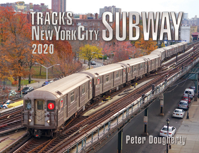
The 2010 edition was released on December 15th 2009. I scrapped the idea of multiple covers but did go with a contest to select the new cover image. Anthony Maimone's great picture of a southbound 1 train from the north end of 238th Street, looking across the 240th street yard leads into the terminal, set against a backdrop of fall colours was the winner. The 2010 edition will indeed remain at the same price as the last few years, thanks to a promise of no postage increase by the USPS.
The big news for 2010 is I was finally able to get maps of Grand Central included, plus the Park Ave. tunnel! Also details are included on the two big rebuilding projects in Brooklyn (Culver Viaduct for the F/G and on the Brighton Line, from Newkirk Avenue down to Neck road. The new terminal on the 1 is open at South Ferry and work continues on the westward extension of the 7 to the Javits center. The projected opening phase of the 2nd Ave. line was pushed back to 2017. Surprise Surprise. A new master tower opened on the 8th Ave. line (World Trade E platform) and new homeballs in-place from the south end of Canal St. to Broadway-Nassau St.
The photo contest web page was launched on August 12th, 2010. Submissions for the 2011 cover may be made by e-mail only to nyctrackbook@gmail.com and the deadline is October 31st. I'm targeting Nov. 21st as the release date for the 2011 edition, but that's still up in the air, depending on when I get all my revisions done. As of now, I'm HOPING to be able to hold the shipping costs where they are but the post office is talking about a big price increase so I'll just have to wait and see. Any announcement will be forthcoming by late Autumn. I don't expect the base price to rise as my printing costs are still reasonable.
UPDATE: DEC 3rd, 2010: There price for the 2011 edition will remain the same as it has for the last few years. Books were delivered on December 3rd and all pre-orders will be filled by Dec. 4th. The 2011 edition includes the realignment forced by the June 2010 service cuts. This means the V and W trains are gone, the M re-aligned and service withdrawn through the Montague St. Cut. More station names have changed, major rebuilding projects at E. 180th St in the Bronx, on the Brighton Line and over the Gowanus Canal in Brooklyn are documented and the latest car/yard roster moves included.
December 14 2011: The 2012 version of the book shipped today! There wasn't a lot of change to the system during 2011 other than a few station names and progress on a couple of track and structure renewal projects. The biggest change for the 2012 edition was the complete reconfiguration and resignaling at East 180th St. The Brighton line rebuild is now complete, the Gowanus Canal Culver Viaduct project continues and station renaming continues unabated. CBTC is fully operational on the L and coming soon to the 7. Rolling stock details were stable this year and for once didn't require extensive re-writes as fleets moved hither and yon. Once again for 2012, the cost of the book will remain the same as it has for many years, however postage costs may go up slightly in early January once the Post Office releases their final 2012 pricing. Due to a printing error in the initial print run, pages 2, 3 and 82 were incomplete. Links were provided on the Updates page so buyers of the first 125 copies of the book could have the corrected pages. These errors were caught just after deadline and all future reprintings will be correct.
January 22, 2012: The Post Office increased postage rates outside of the United States significantly. As a result I had to add $3.00 to the international cost ($4 via PayPal). Domestic prices went up as well but not enough to affect my domestic shipping cost for single (or two) copies. Domestic shipping rates for wholesale orders and larger retail orders is also up but only by a small amount.
November 14, 2012: The 2013 edition will begin shipping on Dec. 7th. Not many changes in the offing this year since 2012 was essentially quiet it terms of system changes. Lots of capital works in progress but nothing new added. Hurricane/super-storm Sandy's devastation will be covered in this edition--at least insofar as temporary service disruptions are concerned. Gowanus Canal updates for 2012/2013 will also be included and some intro pages were rewritten.
Zach Summer won this year's photo contest once again with a great shot of an Manhattan-bound F train from 18th St. in Brooklyn, shot on the 11th anniversary of 9/11, with the TRIBUTE IN LIGHT illuminating the void left by the World Trade Center towers on the distant skyline.
Postage costs are once again increasing fairly substantially in January 2013 and this will be reflected in a higher shipping price once the new rates kick in. The base price of the book is remaining at $39.95 again this year.
June 10, 2012: Much of the Sandy-related damages were brought back on line and an interim edition was released. This release also highlighted the ongoing Sandy repairs including the 14-month rehab of the Montague St. tunnels and the upcoming 2014 closures of the Greenpoint tunnel affecting the G train.
December 2013: The 2014 edition will shipped on December 13th, 2013. This year the 7 train extension is shown, which is slated to open in June 2014. There have been a few other changes over the June 2013 mid-year reprint, but a new cover and various editorial changes, yard track modifications and notes on some Bronx IRT changes. I have redrawn some previously inaccurate trackage on the 2/5 lines south of E. 180th St and the IND lines from Jay St. to Bergen St and from the Transit Museum station to beyond Hoyt-Schemerhorn. In addition, I've also tried to clarify the South Ferry loop on the main drawing.
Anthony Maimone won the cover photo contest for this year with his shot of a 7 train at Hunters Point.
December 2014: The 2015 edition shipped on Dec. 16th. Very little has changed in the system since the release of the 2014 edition and the 7 extension shown in the 2014 edition is still not open. Some track and signal work is going on up on the Dyre Ave. line, the Montague St. tunnels have been re-opened and post-Sandy repair work on the Greenpoint tubes has also been completed. I re-drew the Gold St. Interlocking north of DeKalb Avenue to scale and changed out the graphical symbols used to denote two- and three-aspect home signals.
Zach Summer won the front cover photo contest for this year with his shot of a 1 train at 125th Street in Manhattan, and his picture of a pair of Js from 2011 graces the back cover as well.
The price of the 2015 edition was increased by two dollars to reflect considerably higher printing costs. This is the first increase in about 10 years that wasn't on account of the post office raising its shipping prices.
November 2015: The 2015 edition sold out in late October and the new version was sent to print on November 19th, the earliest it was ever completed. For the first time, the 2016 edition will be available in both print and electronic PDF editions. The major change for 2016 was the extension of the 7 line opened in September and detailed to-scale closeups of several complex interlockings, with more to come in 2017, hopefully.
The first printing sold out quickly and a second printing, with a few modified pages, was done on December 1st. Changed pages are up on the "Updates" page.
Anthony Maimone once again took the front cover with a great shot of a 7 train layup south of 34th St. Hudson Yards, and Zach Summer won the rear cover with a picture of an N approaching Coney Island at twilight.
The 2016 price for the printed book remains at $41.95+S&H, and the PDF version sells for $24.95.
November 2016: The 2016 edition sold out in late October. The new version was sent to press around Thanksgiving and delivery of hardcopies started in early December. PDF versions will be available once the print edition has been sent to press (Nov. 29th).
Like the 2016 edition, this is a very significant update to the book overall, and builds upon some of the big additions from last year. The major changes for 2017 are the inclusion of the Second Avenue Subway, and the restoration of W train service. The W came back on November 7th, running from Ditmas Avenue-Astoria to Whitehall St. in Manhattan. The Second Avenue Subway opened on January 1st 2017.
Closeup maps for 9th Avenue, Fresh Pond Yard, and Rockaway Park Yard have been added, more homeballs identified, and the yards section includes a car/yard matrix for each facility. New details on the R-179 and R-211 car classes included, tower pages updated and text changes galore. If you haven't purchased a copy in a couple of years, this is the one to get!
Zach Summer won this year's front cover photo contest with his picture of two R-142A cars in the barn at Pelham Yard. Both these cars have subsequently been converted to R-188s and are operating on the Flushing line. Zach's back cover image appeard previously on the Yard Maps page in Black and White, but was so good it was selected for a color cover.
The 2017 price for the printed book remains at $41.95+S&H, and the PDF version sells for $24.95.
November 2017: The 2017 edition sold out on Oct. 31st. The new version will be sent to press around Thanksgiving and delivery of hardcopies started in early December. PDF versions will be available once the print edition has been sent to press.
Daniel Smith won this year's front cover photo of a Ditmars-bound W in Astoria, and the back cover of two West End trains at Stillwell.
SIGNALS SIGNALS and more SIGNALS! With the two line extensions now open, there wasn't as much new material to include for 2018 so I decided to focus on adding home signals, and even more closeup maps of complex interlockings. I've added a full page of to-scale maps of the bigger midtown Manhattan interlockings,and added a ton of homeballs on individual pages. Closeup maps of 137th and 174th St. Yards were added, and a few sections were redrawn for better clarity. A fair portion of the text was updated as well.
The 2018 price for the printed book remains at $41.95+S&H, and the PDF version sells for $24.95.
November 2018: The 2019 edition will go to press the week of Thanksgiving and should be available for delivery on December 3rd. Following last year's theme, more and more interlocking closeups are included this year, including BMT City Hall to Prince Street, Briarwood, 59th St. Columbus Circle, BMT Ocean Parkway and a few others. The opening of a new Master Tower at 34th and 6th meant the 6th Ave. line was re-signaled from south of 42nd St. to West 4th. All these changes have been documented. Hundreds of minor corrections and changes are included this year as well.
Kenny Richetti is the winner of the 2019 front cover award with his stunning time-lapse image of a ghost-7 at Queensboro Plaza. Another first-time winner, Jie wen Li earned a spot on the 2019 back cover with a picture of two IRT trains at the 125th Street/Broadway portal. Congrats to both winners!
A note regarding production. This year, many of the closeups of complex interlockings and the colour signal pages were finally moved over from Illustrator to InDesign, requiring many hundreds of hours of work, for an end result that you the reader will never see. Editing any of these closeups in the past has been a rather monumental challenge (for example, a route changes, a typo's found, signal numbers change, etc) and this year's work will make subsequent modifications take seconds instead of a half-hour or more to find and load the appropriate files.
And further along these lines, in setting up for 2020, after the 2019 edition went to press the five documents that go into making the book were consolidated into just two, and during 2020, an even more Herculean task will be attempted; that of combining the vertical and horizontal files into one master file. So with any luck, after all of these conversions are finished, preparing the 2020 and subsequent books will take maybe a couple of weeks rather than 5 or 6 months!
Again, this will (hopefully) never be noticed by the reader but for the 500-600 hours of labour over the past year, your author/publisher needed to crow/vent a little bit here :)
Final edits for the first edition were complete on the afternoon of Nov. 19th. The 2019 edition price for the printed book remains at $41.95+S&H, and the PDF version sells for $24.95. NOTE: Postage rates are once again going up significantly in the new year, and as a result, shipping and handling prices will rise accordingly.
October 2019:
As always, the new for 2020 edition will have all the latest updates and a few more signals and closeups, following the trend from 2018 and 2019. As mentioned in the previous year's description, the big behind-the-scenes changes have indeed made editing and composing a much simpler proposition this year. Another massive step along that road involved redrawing every single one of the yard maps and labeling the tracks more clearly than they were before. Coney Island and Stillwell were merged and a combined map of the CIY area and Stillwell terminal was added. All the new artwork is in vector format, so for those who buy the PDF version, you'll be able to zoom right in and see things perfectly clearly.
The other big news for the year revolved around the 2020-2024 capital plan that promises big bucks for accelerated CBTC implementation, new subway cars, and scores of other major capital expenditures.
Once again there will be no price increase. The 2020 edition cost for the printed book remains at $41.95+S&H, and the PDF version sells for $24.95.