Follow us at facebook.com/NYCTrackbook
Online Maps
Online maps are located at
http://www.nycsubway.org/maps/track.html
Here you will find colour versions of the track maps on which the printed book is based. In 1997 I changed data file formats in order to make the book more easily editable. Unfortunately, it made making changes to these free colour maps very difficult. Consequently I have not been able to update these in several years, since that would mean redrawing almost the entire system from scratch--something for which I don't presently have the time.
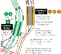
A colour line indicates that a revenue-service (passenger) train uses a specific track, while a black line indicates a track in service but not normally used in passenger service. Grey lines denote abandoned tracks or platforms. Colours used are based on line colours used in the present-day official map from the MTA. For example, green is the east-side IRT, red is the west side IRT, Brown is the Nassau St./ Broadway (Brooklyn) line, yellow is the Manhattan Broadway line, etc.
These online maps are colourized version of the original scans I made in 1995 and will probably stay much as they are now--errors and all--for a while yet. I have recently updated many of the Manhattan and Brooklyn maps to reflect the changes brought about by the Manhattan Bridge flip in July, 2001. Additionally, I've added the 63rd St. connector to the Queens maps. If you're interested in working with me in updating this free site, please drop me an e-mail. Any and all help would be most welcomed!